 Asset Publisher
LOCATION
 Położenie, fot. Przemysław Krawczyk
 Położenie, fot. Przemysław Krawczyk
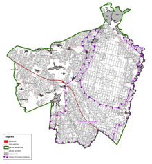
Żagań forest district is one of twenty district within Regional Directorate of the State Forests in Zielona Góra. In the west it borders on Wymiarki Forest District, in the north on Lipinki Krzystkowice Forest District, Szprotawa and Świętoszów (RDSF Wrocaw) Forest Districts in the east and Ruszów (RDSF Wrocław) in the south.
Żagań forest district is in south-west part of Poland in the valley of middle Bobr and upper Czerna. Through the area of the forest district runs Trzebnica Wall, divided by the River Bóbr, creating Żary Elevation to the west and Dalków Hills to the east. It manages the soil of State Treasury on the areas of two provinces: Lubuskie (Żagań county, Żagań commune, Iłowa, Wymiarki, the town of Żagań, the town of Iłowa, Żary county) and lower-Silesia (Bolesławiec county, Osiecznica commune).
Żagań Forest District constitute a compact forest complex based on the greatest Polish complex - Lower Silesia Forest
The district comprises of two forest precincts:
- Iłowa Żagańska Precinct - area: 7 261.49 ha
- Żagań Precinct - area: 13 164.67 ha
Total area of the Forest District is 20 426.16 ha.